The Amazing Disappearing Soundwall Trick!
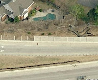
Since Microsoft decided to advertise Bing during the Olympics, I thought the least I could do was try it out a little bit. One thing I noticed is that the images they have on Bing Maps are actually newer than the ones that Google Maps has on either their normal maps or Streetview maps in the St. Louis area. One way to tell is by looking at highway 64 and the soundwall construction. My sample location is a house that is for sale in our area, namely 9062 Monmouth in Richmond Heights (63117). If you search for it on Google Maps you will see the highway is shut down and under construction but there is no wall yet constructed. If you then use Google Streetview and look at the house, as you move by its left side you will still see all the old trees and brush behind it which is how it looked even before the highway construction began. To see the pre-construction aerial view, you can use Bing and just look at the aerial projection. You will see a whole bunch of trees between the house and the highway, which is the old highway 40 in use. However, if you switch to "bird's eye" mode you see the soundwall and the new I-64 post construction. Most of the trees had to be ripped down when the new road and soundwall were installed. As you rotate through the Bird's eye view you will note that three of the shots are newer with the soundwall constructed, but one (looking from west to east) shows the old highway without the soundwall. That is my disappearing soundwall trick! However, if you then move just a little further east of McKnight and try it again, then all four projections show the new soundwall in place! Weird. There must just be a small region where they do not have a new east looking image so they show the old images. In any case I thought it was nice that Bing actually shows the "new I-64" in all its glory in use now. And for grabbing these images, I still use my favorite little freeware screen capture utility, MWSnap.


Comments